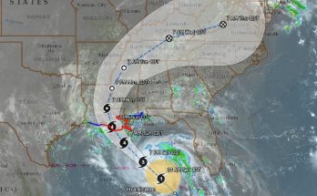
The eye of Florence remains very distinct in infrared satellite imagery this morning. There has been little change to the cloud top temperatures surrounding the eye overnight, however, the overall cloud shield and central dense overcast has become slightly more
symmetric.
An Air Force Reserve Hurricane Hunter aircraft that was in the hurricane until just after midnight measured a peak 700-mb flight-level wind of 130 kt, and a SFMR wind of 107 kt in the northeast eyewall. A blend of these data and recent subjective and objective satellite intensity estimates supports an initial wind speed of 115 kt. Florence will be moving over sea surface temperatures of around 29C and through an area of low vertical wind shear during the next day or so.
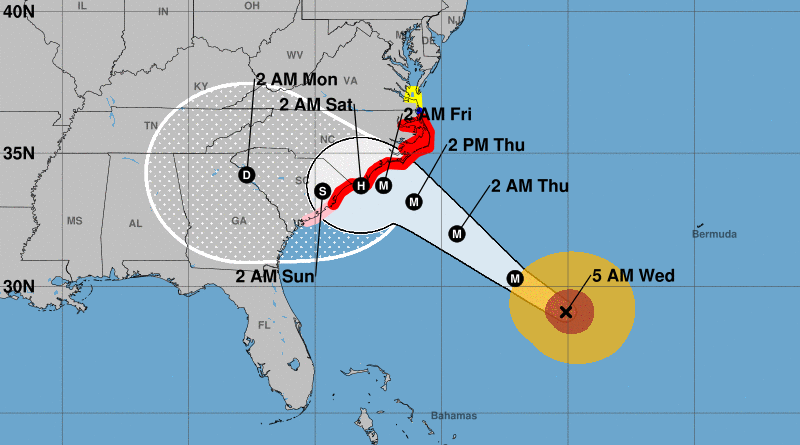
These conditions favor some strengthening, but eyewall replacement cycles could cause some fluctuations in intensity during that time. After that time, an increase in southwesterly shear, upwelling, and interaction with land is likely to lead to some weakening, however, Florence is expected to remain a dangerous major hurricane as it approaches the coastline. The new NHC intensity forecast is near the higher statistical guidance through 48 hours, then follows the trend of the decay SHIPS model after that time.
[media-credit name=”Hurricane Model Plots Provided By South Florida Water Management District” align=”aligncenter” width=”800″]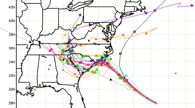 [/media-credit]
Florence is moving west-northwestward or 300 degrees at 15 kt. There has been no change to the track forecast or reasoning for the first 36-48 hours, as Florence will continue to be steered west-northwestward to northwestward around the southwestern portion of a mid-level ridge centered northeast of Bermuda. By late Thursday, a mid-level ridge is forecast to begin building over the east-central United States, which is expected to cause Florence to slow down significantly by 48 hours. The track guidance is in good agreement through the first couple of days of the forecast period, and the NHC track forecast again brings the center of the hurricane very close to the coasts of North and South Carolina within 48 hours.
Later in the period, the dynamical model spread increases but most of the guidance has continued its southward shift, and now take Florence southwestward near the coast of South Carolina by day 4. The NHC track has been adjusted southward at days 4 and 5, and is a little north of the consensus out of respect for continuity, however, the GFS, ECMWF, and the ECMWF ensemble mean is south of the NHC track forecast, and additional southward adjustment may be warranted in future advisories.
It is important for users to realize that significant impacts extend well away from the center of Florence, and serious hazards such as a dangerous storm surge and flooding rains will cover a large area regardless of exactly where the center moves.
Key Messages:
1. A life-threatening storm surge is now highly likely along portions of the coastlines of South Carolina and North Carolina, and a Storm Surge Warning is in effect for a portion of this area. All interests from South Carolina into the mid-Atlantic region should
complete preparations and follow any advice given by local officials.
2. Life-threatening, catastrophic flash flooding and significant river flooding is likely over portions of the Carolinas and Mid-Atlantic states from late this week into early next week, as Florence is expected to slow down as it approaches the coast and
moves inland.
3. Damaging hurricane-force winds are likely along portions of the coasts of South Carolina and North Carolina, and a Hurricane Warning is in effect. Strong winds could also spread inland into portions of the Carolinas.
4. Large swells affecting Bermuda and portions of the U.S. East Coast will continue this week, resulting in life-threatening surf and rip currents.