The satellite and radar presentations of Florence have improved somewhat this morning, with a 20-25 nmi wide eye closing off in the radar data from the Morehead City and Wilmington WSR-88D Doppler weather radars.
However, an Air Force Reserve reconnaissance aircraft investigating the hurricane this morning has not yet found any flight-level or SFMR winds to support more than about 80 kt at the surface thus far, even though the pressure has decreased to 955 mb.
The initial intensity has only been lowered to 90 kt, given that there are peak Doppler velocity values up to 110 kt with average values of 95-97 kt at 15,000 ft in the northern eyewall region, an area of the hurricane that the reconnaissance aircraft has not yet sampled. The upper-level outflow pattern remains quite impressive.
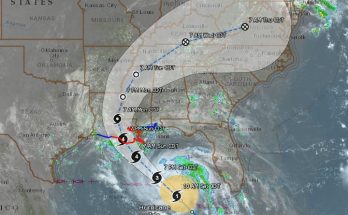
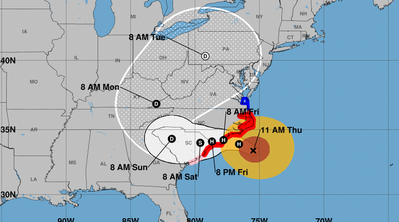
Florence has been gradually slowing down this morning, and the initial motion estimate is now 315/09 kt. The subtropical ridge to the northeast and east of Florence is now well-established between Bermuda and the U.S. mid-Atlantic region and extends westward into Virginia and the central Appalachians. This large-scale feature is expected to keep the hurricane moving northwestward today, followed by a turn toward the west at a much slower speed on Friday as the ridge to the north of Florence weakens due to a weak shortwave trough dropping slowly southward from the Ohio Valley.
On days 3-5, Florence is forecast turn toward the northwest and north around the western periphery of the subtropical ridge, and move across western South Carolina on Sunday, across western North Carolina and eastern Tennessee on Monday, and then move up the spine of the Appalachians as an extratropical low after the cyclone merges or interacts with a frontal system. The new NHC forecast track is similar to the previous one, and lies close to a blend of the consensus models TVCA, HCCA, and FSSE.
Florence is currently approaching the Gulfstream current, and the hurricane is forecast to move over warmer and deeper waters in 6-12 hours, which could allow for some slight strengthening. Just prior to landfall in about 24 hours, Florence is expected to weaken some
due to upwelling of the shallow coastal waters. After landfall occurs, rapid weaning of the stronger inner-core wind field is expected to due land interaction and Florence’s slow forward speed of 5 kt or less. However, intense rainbands are expected to develop over the Atlantic waters and keep moving along the coast and inland, likely producing strong wind gusts through Saturday night.
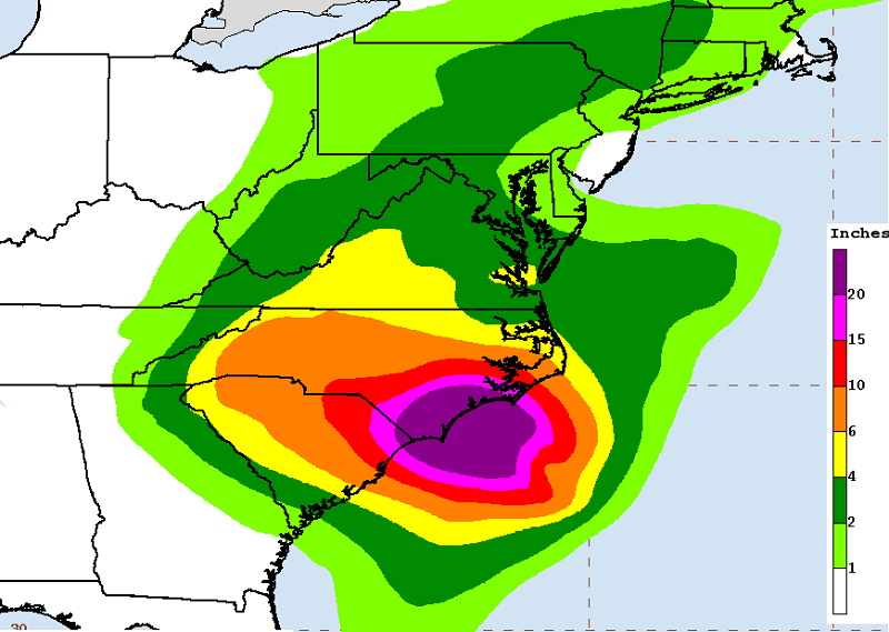
Aircraft and satellite wind data show that Florence remains a large hurricane. Life-threatening storm surge, heavy rainfall, and damaging wind will cover a large area regardless of exactly where the center of Florence moves.