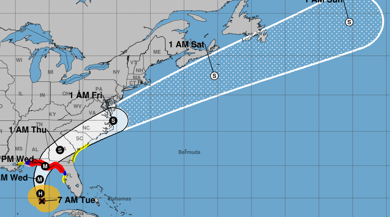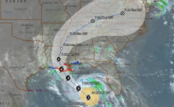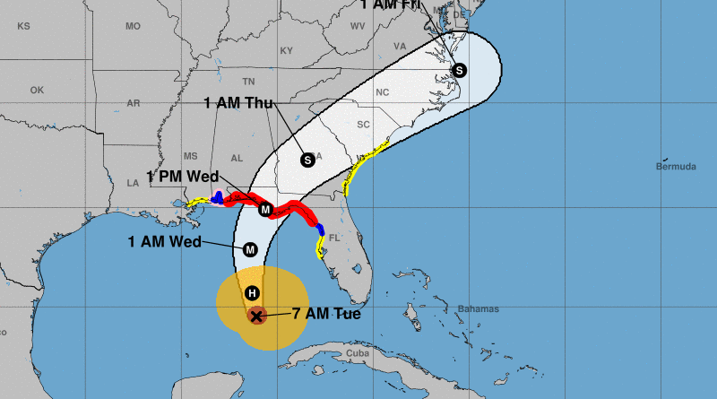
At 700 AM CDT (1200 UTC), the eye of Hurricane Michael was located near latitude 24.5 North, longitude 86.1 West. Michael is moving toward the north-northwest near 12 mph (19 km/h). A north-northwestward to northward motion is expected through tonight, followed by a northeastward motion on Wednesday and Thursday. On the forecast track, the center of Michael will move across the eastern Gulf of Mexico through tonight. The center of Michael is expected to move inland over the Florida Panhandle or Florida Big Bend area on Wednesday, and then move northeastward across the southeastern United States Wednesday night and Thursday.
Data from a NOAA Hurricane Hunter aircraft indicate that the maximum sustained winds have increased to near 100 mph (155 km/h) with higher gusts. Additional strengthening is expected, and Michael is forecast to be a major hurricane at landfall in Florida. Weakening is expected after landfall as Michael moves through the southeastern United States.
Hurricane-force winds extend outward up to 40 miles (65 km) from the center and tropical-storm-force winds extend outward up to 195 miles (315 km). NOAA buoy 42003 recently reported 1-minute mean winds of 47 mph (76 km/h) and a wind gust of 54 mph (87 km/h).
The latest minimum central pressure reported by the NOAA aircraft is 968 mb (28.58 inches).
The combination of a dangerous storm surge and the tide will cause normally dry areas near the coast to be flooded by rising waters moving inland from the shoreline. The water has the potential to reach the following heights above ground if peak surge occurs at the time of high tide…
Indian Pass FL to Cedar Key FL…8-12 ft Cedar Key FL to Crystal River FL…6-8 ft Okaloosa/Walton County Line FL to Indian Pass FL…6-9 ft Crystal River FL to Anclote River FL…4-6 ft Anclote River to Anna Maria Island FL including Tampa Bay…2-4 ft Alabama/Florida border to Okaloosa/Walton County Line FL…2-4 ft
Hurricane conditions are expected within the hurricane warning area along the U.S. Gulf Coast by Wednesday, with tropical storm conditions expected by tonight or early Wednesday. Hurricane conditions will also spread well inland across portions of the Florida Panhandle, southeastern Alabama and southwestern Georgia.
Tropical storm conditions are expected in the tropical storm warning area by tonight or early Wednesday, and are possible within the tropical storm watch area by that time. Hurricane conditions are possible within the hurricane watch area by Wednesday.
Tropical storm conditions are possible in the watch area along the southeast U.S. coast Wednesday night and Thursday.
Michael is expected to produce the following rainfall amounts through Friday…
Western Cuba…4 to 8 inches, with isolated maximum amounts of 12 inches. This rainfall could lead to life-threatening flash floods and mudslides.
Florida Panhandle and Big Bend, southeast Alabama, and southern Georgia…4 to 8 inches, with isolated maximum amounts of 12 inches. This rainfall could lead to life-threatening flash floods.
Eastern Georgia, the Carolinas, and southern Virginia…3 to 6 inches. This rainfall could lead to life-threatening flash floods.
Florida Peninsula, eastern Mid Atlantic, southern New England coast…1-3 inches.
SURF: Swells generated by Michael are beginning to affect the coasts of the eastern and northern Gulf of Mexico. These swells will spread to portions of the northwestern and western Gulf of Mexico coast during the next day or so. These swells are likely to cause life-threatening surf and rip current conditions. Please consult products from your local weather office.
TORNADOES: The threat for tornadoes will increase late tonight into Wednesday over parts of the Florida Panhandle, the northern Florida Peninsula, and southern Georgia.