The National Weather Service in Mount Holly NJ has issued a
* Severe Thunderstorm Warning for…
Northeastern New Castle County in northern Delaware…
North central Salem County in southern New Jersey…
Northwestern Gloucester County in southern New Jersey…
Southeastern Delaware County in southeastern Pennsylvania…
* Until 545 PM EDT.
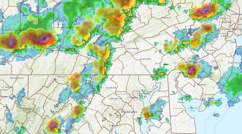
* At 503 PM EDT, a severe thunderstorm was located over Chester Township, or 9 miles northeast of Wilmington, moving east at 15 mph.
HAZARD…60 mph wind gusts.
SOURCE…Radar indicated.
IMPACT…Damage to roofs, siding, trees, and power lines is possible.
* Locations impacted include…
Chester, West Deptford, Woodbury, Carneys Point, Folcroft,
Swarthmore, Paulsboro, Penns Grove, Swedesboro, Arden, Beckett,
Nether Providence Township, Chester Township, Philadelphia
International Arpt, Gibbstown, Chelsea, Brookhaven, Ridley Park,
Prospect Park and Norwood.
PRECAUTIONARY/PREPAREDNESS ACTIONS…
Remain alert for a possible tornado! Tornadoes can develop quickly
from severe thunderstorms. If you spot a tornado go at once into the
basement or small central room in a sturdy structure.
For your protection move to an interior room on the lowest floor of a
building.
To report severe weather, contact your nearest law enforcement
agency. They will send your report to the National Weather Service
office in Mount Holly NJ.
This thunderstorm is capable of producing all types of severe
weather including destructive straight line winds and tornadoes.
Move quickly to a safe shelter such as an interior room, a bathroom,
closet or basement.
Torrential rainfall is occurring with this storm, and may lead to
flash flooding. Do not drive your vehicle through flooded roadways.
&&
LAT…LON 3977 7552 3988 7546 3992 7542 3985 7516
3966 7536
TIME…MOT…LOC 2103Z 291DEG 13KT 3982 7541
TORNADO…POSSIBLE
HAIL…<.75IN
WIND…60MPH