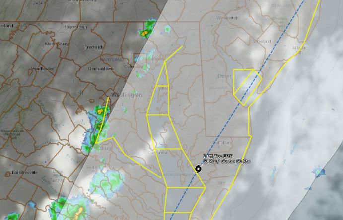
The latest bulletin from the National Weather Service indicates that Isaias has strengthened slightly. Delaware could see two to five inches of rain, gusty winds, and minor to isolated moderate river flooding early next week.
BULLETIN
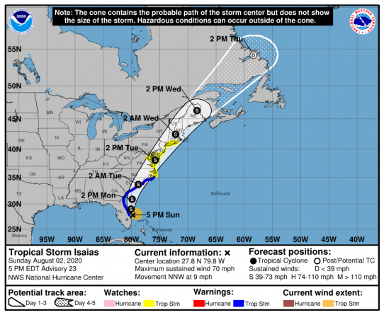
Tropical Storm Isaias Advisory Number 23
NWS National Hurricane Center Miami FL AL092020
500 PM EDT Sun Aug 02 2020
…ISAIAS STRENGTHENS SLIGHTLY WHILE MOVING NORTH-NORTHWESTWARD JUST OFFSHORE THE EAST-CENTRAL FLORIDA COAST……HURRICANE WATCH AND STORM SURGE WARNING ISSUED FOR PORTIONS OF THE CAROLINAS…
SUMMARY OF 500 PM EDT…2100 UTC…INFORMATION
———————————————-
LOCATION…27.8N 79.8W
ABOUT 65 MI…105 KM SE OF CAPE CANAVERAL FLORIDA
ABOUT 410 MI…660 KM S OF MYRTLE BEACH SOUTH CAROLINA
MAXIMUM SUSTAINED WINDS…70 MPH…110 KM/H
PRESENT MOVEMENT…NNW OR 345 DEGREES AT 9 MPH…15 KM/H
MINIMUM CENTRAL PRESSURE…994 MB…29.36 INCHES
WATCHES AND WARNINGS
——————–
CHANGES WITH THIS ADVISORY:
A Storm Surge Warning is in effect from Edisto Beach South Carolina
to Cape Fear North Carolina.
A Storm Surge Watch is in effect from Cape Fear to Duck North
Carolina, including Pamlico and Albemarle Sounds.
A Hurricane Watch is in effect from South Santee River South
Carolina to Surf City North Carolina.
The Tropical Storm Warning has been extended northward to Ocracoke
Inlet North Carolina.
The Tropical Storm Watch has been extended northward to Watch Hill
Rhode Island, including the Chesapeake Bay, the Tidal Potomac
River, Delaware Bay, Long Island and Long Island Sound.
The Tropical Storm Warning has been discontinued south of Sebastian
Inlet Florida.
SUMMARY OF WATCHES AND WARNINGS IN EFFECT:
A Storm Surge Warning is in effect for…
* Edisto Beach South Carolina to Cape Fear North Carolina
A Storm Surge Watch is in effect for…
* Cape Fear to Duck North Carolina
* Pamlico and Albemarle Sounds
A Hurricane Watch is in effect for…
* South Santee River South Carolina to Surf City North Carolina
A Tropical Storm Warning is in effect for…
* Sebastian Inlet Florida to Ocracoke Inlet North Carolina
A Tropical Storm Watch is in effect for…
* Ocracoke Inlet North Carolina to Watch Hill Rhode Island
* Pamlico and Albemarle Sounds
* Chesapeake Bay
* Tidal Potomac River
* Delaware Bay
* Long Island and Long Island Sound
Interests elsewhere along the northeast coast of the United States
should monitor the progress of Isaias. Additional watches or
warnings may be required tonight or early Monday.
A Storm Surge Warning means there is a danger of life-threatening
inundation, from rising water moving inland from the coastline,
during the next 36 hours in the indicated locations. For a depiction
of areas at risk, please see the National Weather Service Storm
Surge Watch/Warning Graphic at hurricanes.gov. This is a
life-threatening situation. Persons located within these areas
should take all necessary actions to protect life and property from
rising water and the potential for other dangerous conditions.
Promptly follow evacuation and other instructions from local
officials.
A Storm Surge Watch means there is a possibility of life-
threatening inundation, from rising water moving inland from the
coastline, in the indicated locations during the next 48 hours.
A Hurricane Watch means that hurricane conditions are possible
within the watch area. A watch is typically issued 48 hours
before the anticipated first occurrence of tropical-storm-force
winds, conditions that make outside preparations difficult or
dangerous.
A Tropical Storm Warning means that tropical storm conditions are
expected somewhere within the warning area, generally within 36
hours.
A Tropical Storm Watch means that tropical storm conditions are
possible within the watch area, generally within 48 hours.
For storm information specific to your area in the United
States, including possible inland watches and warnings, please
monitor products issued by your local National Weather Service
forecast office. For storm information specific to your area
outside of the United States, please monitor products issued by
your national meteorological service.
DISCUSSION AND OUTLOOK
———————-
At 500 PM EDT (2100 UTC), the center of Tropical Storm Isaias was
located by an Air Force Reserve reconnaissance aircraft and NOAA
Doppler weather radars near latitude 27.8 North, longitude 79.8
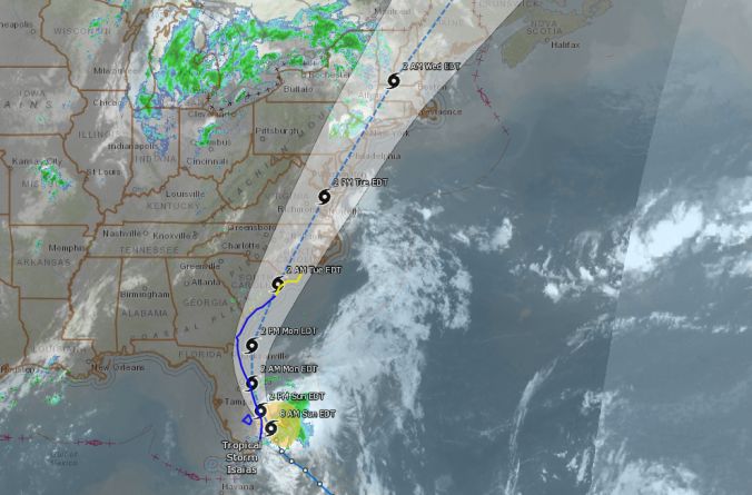
West. Isaias is moving toward the north-northwest near 9 mph (15
km/h), and this general motion is expected to continue through
tonight. A turn toward the north and north-northeast along with an
increase in forward speed is anticipated on Monday and Tuesday. On
the forecast track, the center of Isaias will pass just to the east
of the Florida east coast through tonight. The center of Isaias
will move offshore of the coast of Georgia and southern South
Carolina on Monday, move inland over eastern North Carolina
Monday night and move along the coast of the mid-Atlantic states on
Tuesday.
Data from the aircraft and the Melbourne, Florida, Doppler radar
indicate that maximum sustained winds have increased to near 70 mph
(110 km/h) with higher gusts. Some fluctuations in strength will be
possible during the next 36 hours, but Isaias is expected
to be a strong tropical storm when it reaches the coast of
northern South Carolina and southern North Carolina Monday night.
Slow weakening is forecast after Isaias makes landfall in the
Carolinas and moves across the U.S. mid-Atlantic region late Monday
and Tuesday.
Tropical-storm-force winds extend outward up to 115 miles (185 km)
from the center. A weather station at Sebastian Inlet, Florida,
recently measured a wind gust of 49 mph (80 km/h).
The minimum central pressure based on reports from the
reconnaissance aircraft is estimated to be 994 mb (29.36 inches).
HAZARDS AFFECTING LAND
———————-
Key messages for Isaias can be found in the Tropical Cyclone
Discussion under AWIPS header MIATCDAT4, WMO header WTNT44 KNHC, and
on the web at www.hurricanes.gov/text/MIATCDAT4.shtml.
STORM SURGE: The combination of a dangerous storm surge and the
tide will cause normally dry areas near the coast to be flooded by
rising waters moving inland from the shoreline. The water could
reach the following heights above ground somewhere in the indicated
areas if the peak surge occurs at the time of high tide…
Edisto Beach SC to Cape Fear NC…2-4 ft
Sebastian Inlet FL to Edisto Beach SC…1-3 ft
North of Cape Fear NC to Kiptopeke VA including Pamlico Sound,
Albemarle Sound, Neuse River, Pamlico River, Chesapeake Bay, and
the Tidal Potomac River…1-3 ft
The deepest water will occur along the immediate coast in areas of
onshore winds, where the surge will be accompanied by large waves.
Surge-related flooding depends on the relative timing of the surge
and the tidal cycle, and can vary greatly over short distances.
For information specific to your area, please see products issued
by your local National Weather Service forecast office.
WIND: Hurricane conditions are be possible in the watch area in
South and North Carolina Monday night and early Tuesday.
Tropical storm conditions will spread northward within the Tropical
Storm Warning area from Florida to North Carolina through Monday
night.
Tropical storm conditions are possible in the Tropical Storm Watch
area beginning on Tuesday.
RAINFALL: The following rainfall accumulations are expected along
and near the track of Isaias:
Northwest Bahamas: Additional 1 to 3 inches, isolated storm totals
12 inches.
Eastern Florida: Additional 1 to 3 inches, isolated storm totals
4 inches.
Coastal Georgia: 1 to 2 inches.
Carolinas and the Mid-Atlantic: 3 to 6 inches, isolated maximum
totals 8 inches.
Southeast New York and much of New England: 2 to 4 inches, isolated
maximum totals 6 inches.
Heavy rainfall from Isaias will continue to result in potentially
life-threatening flash flooding in the Northwestern Bahamas through
tonight. Flash and urban flooding, some of which may be significant
in the eastern Carolinas and the Mid-Atlantic, is expected through
midweek along and near the path of Isaias across the East Coast of
the United States. Widespread minor to isolated moderate river
flooding is possible across portions of the Carolinas and the
Mid-Atlantic.
SURF: Swells generated by Isaias are affecting portions of
the Bahamas and the southeast coast of the United States and will
spread northward along the U.S. east coast during the next couple
of days. These swells are likely to cause life-threatening surf and
rip current conditions. Please consult products from your local
weather office.
TORNADOES: A few tornadoes will be possible over coastal South
Carolina during the afternoon and evening on Monday, and across
eastern North Carolina Monday evening and overnight.