Dover Air Force Base – “Recalculating. Recalculating. Recalculating. Make a legal U-turn.” Anyone who uses a GPS system in their car has likely heard this a million times. Thanks in part to a Team Dover aircrew, the next generation of Air Force GPS satellites will soon be launched into orbit, allowing drivers everywhere to make legal U-turns.
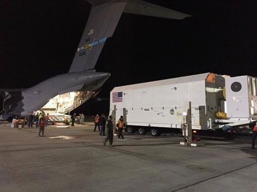
A C-17 Globemaster III, operated by the 3d Airlift Squadron, transported a GPS Block IIIA Satellite Pathfinder and its shipping container from the Space Coast Regional Airport in Titusville, Florida, to Buckley AFB, Colorado, Jan. 29 to 31, 2017.
According to Eric Smith, Lockheed Martin Space Systems associate manager of transportation, the Pathfinder was sent to Florida in December to validate the required transportation procedures needed to get a satellite to the launch facility. He explained that the Pathfinder is not a true mocked-up satellite, but a model that is being used to test and certify transportation methods for future satellites.
“It’s as close to a fully built satellite as we could get,” Smith said. “The shipping container is essentially a mobile cleanroom.”
Prior to the mission, the aircrew expected the move would to be challenging. This was the first time an active duty C-17 squadron loaded and moved this type of cargo.
“We prepositioned two loadmasters down to Titusville, at Cape Canaveral, because it was a complicated load,” said Capt. Shawn McDonald, 3d AS pilot and chief of tactics. “They went to figure out some of the logistics about two days in advance.”
Prepositioning loadmasters is not commonplace for the 3d AS.
“We only do it if it’s for something that’s going to be extremely complicated or extremely expensive,” said Senior Airman Mathew Snyder, 3d AS loadmaster. “We were told that the piece itself was worth half-a-billion dollars.”
The entire Pathfinder and container payload weighs more than 67,000 pounds, is 42 feet long, 16 feet wide and 11 feet high.
“It was a challenge,” said Snyder. “Just the sheer size of the container took up most of our cargo compartment, came in at over 500 inches long, over 140 inches high, and it really only left us with a foot left or right of the aircraft. There was no kind of wiggle room for mistakes. So we really had to be spot on, working together and make sure everything went smoothly.”
Between the loading team and loadmasters, it took 24 people to successfully load over a five-hour period. It took an additional six hours to offload the cargo in Colorado.
“I would say [onloading cargo] was most challenging,” said Snyder. “Because for the other two loadmasters, it was the first time we were setting eyes on the piece of cargo. The offload was essentially doing everything in reverse, and by then, we had already done it once.”
The load itself was not the only challenging part of the mission, according to McDonald, who was the aircraft commander.
“Getting to Titusville, it’s a small field, somewhere where we are not usually going,” he said. “Talking about the cargo though, there were some specifications on how we had to park the plane, nose high attitude to get this thing on and off.”
The GPS III is the next generation of Navstar GPS satellites built by Lockheed Martin Space Systems and operated by the Air Force. There are currently 10 GPS Block III satellites on order, with the first scheduled for launch in the spring of 2018.
The 3d AS aircrew was made up of pilots Capt. Shawn McDonald, Capt. Ricardo Morales, and 1st Lt. Benjamin Bertelson, and loadmasters Master Sgt. David Feaster, Master Sgt. Jason Massey, Staff Sgt. Ryan Thompson, and Senior Airman Mathew Snyder. Also part of the crew were two flying crew chiefs from the 736th Aircraft Maintenance Squadron, Staff Sgt. Daniel Scheuerman and Staff Sgt. Lance Wright.
Source: Dover Air Force Base
Image Credits: USAF

