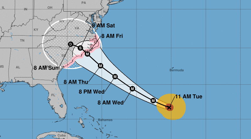
This morning’s 8:00 am Hurricane Florence Advisory placed a large part of the Chesapeake Bay in the cone of uncertainty.
The latest update at 11:00 am shifts the path slightly south, with the center line of the forecast moving into Central North Carolina on Friday.
A smaller portion of the Chesapeake falls in the cone of uncertainty in this latest update.
The next update will be at 2:00 pm.
11:00 Am Advisory
Hurricane Florence Advisory Number 49
NWS National Hurricane Center Miami FL AL062018
1100 AM AST Tue Sep 11 2018
…FLORENCE EXPECTED TO RESTRENGTHEN LATER TODAY…
…LIFE-THREATENING STORM SURGE POSSIBLE ALONG THE COASTS OF NORTH
AND SOUTH CAROLINA…
SUMMARY OF 1100 AM AST…1500 UTC…INFORMATION
———————————————–
LOCATION…26.7N 65.3W
ABOUT 390 MI…625 KM S OF BERMUDA
ABOUT 905 MI…1455 KM ESE OF CAPE FEAR NORTH CAROLINA
MAXIMUM SUSTAINED WINDS…130 MPH…215 KM/H
PRESENT MOVEMENT…WNW OR 295 DEGREES AT 16 MPH…26 KM/H
MINIMUM CENTRAL PRESSURE…950 MB…28.06 INCHES
WATCHES AND WARNINGS
——————–
CHANGES WITH THIS ADVISORY:
None.
SUMMARY OF WATCHES AND WARNINGS IN EFFECT:
A Storm Surge Watch is in effect for…
* Edisto Beach South Carolina to the North Carolina-Virginia border
* Albemarle and Pamlico Sounds, including the Neuse and Pamlico
Rivers
A Hurricane Watch is in effect for…
* Edisto Beach South Carolina to the North Carolina-Virginia border
* Albemarle and Pamlico Sounds
Interests elsewhere in the southeastern and mid-Atlantic states
should monitor the progress of Florence. Additional watches may be
required later today.
A Storm Surge Watch means there is a possibility of life-
threatening inundation, from rising water moving inland from the
coastline, in the indicated locations during the next 48 hours.
For a depiction of areas at risk, please see the National Weather
Service Storm Surge Watch/Warning Graphic, available at
hurricanes.gov.
A Hurricane Watch means that hurricane conditions are possible
within the watch area. A watch is typically issued 48 hours
before the anticipated first occurrence of tropical-storm-force
winds, conditions that make outside preparations difficult or
dangerous.
For storm information specific to your area, including possible
inland watches and warnings, please monitor products issued by your
local National Weather Service forecast office.
DISCUSSION AND OUTLOOK
———————-
At 1100 AM AST (1500 UTC), the center of Hurricane Florence was
located near latitude 26.7 North, longitude 65.3 West. Florence
is moving toward the west-northwest near 16 mph (26 km/h). A west-
northwestward to northwestward motion with a slight increase in
forward speed are expected during the next couple of days. On
the forecast track, the center of Florence will move over the
southwestern Atlantic Ocean between Bermuda and the Bahamas through
Wednesday, and approach the coast of North Carolina or South
Carolina in the hurricane watch area Thursday and Friday.
Maximum sustained winds are near 130 mph (215 km/h) with higher
gusts. Florence is a category 4 hurricane on the Saffir-Simpson
Hurricane Wind Scale. Florence is expected to begin re-
strengthening later today and continue a slow strengthening trend
for the next day or so. While some weakening is expected on
Thursday, Florence is expected to be an extremely dangerous major
hurricane through landfall.
Hurricane-force winds extend outward up to 40 miles (65 km) from the
center and tropical-storm-force winds extend outward up to 150 miles
(240 km).
The estimated minimum central pressure is 950 mb (28.06 inches).
HAZARDS AFFECTING LAND
———————-
STORM SURGE: The combination of a dangerous storm surge and the
tide will cause normally dry areas near the coast to be flooded by
rising waters moving inland from the shoreline. The water has the
potential to reach the following heights above ground if peak surge
occurs at the time of high tide…
Edisto Beach to Murrells Inlet…2-4 ft
Murrells Inlet to Cape Fear…4-6 ft
Cape Fear to Cape Lookout including The Neuse and Pamlico
River…6-12 ft
Cape Lookout to Ocracoke Inlet…5-8 ft
Ocracoke Inlet to North Carolina/Virginia Border…3-5 ft
The deepest water will occur along the immediate coast in areas of
onshore winds, where the surge will be accompanied by large and
destructive waves. Surge-related flooding depends on the relative
timing of the surge and the tidal cycle, and can vary greatly over
short distances. For information specific to your area, please see
products issued by your local National Weather Service forecast
office.
RAINFALL: Florence is expected to produce total rainfall
accumulations of 15 to 20 inches with isolated maximum amounts to 30
inches near the storm’s track over portions of the Carolinas and
Mid-Atlantic States from late this week into early next week. This
rainfall could produce catastrophic flash flooding and significant
river flooding.
WIND: Hurricane conditions are possible within the watch area by
late Thursday or Thursday night, with tropical storm conditions
possible by Thursday morning.
SURF: Swells generated by Florence are affecting Bermuda and
portions of the U.S. East Coast. These swells are likely to cause
life-threatening surf and rip current conditions. Please consult
products from your local weather office.
</pre>