Governor John Carney issued a statement this afternoon urging Delawareans and visitors to prepare for Hurricane Florence, as well as Hurricane Isaac. Carney wants residents to be prepared in the event Delaware feels an impact from the storm.
“The Delaware Emergency Management Agency is closely monitoring the approach of Hurricane Florence, as well as Hurricane Isaac farther out in the Atlantic.
We are communicating and coordinating with Delaware state agencies, local partners, FEMA officials, and authorities in surrounding states. Emergency management officials will continue to monitor the situation and provide updates on any protective actions that should be taken in response to Hurricane Florence.
Delawareans and visitors should be prepared in the event that Delaware feels an impact from the storm. It is still too early to tell what impact Delaware will experience, but it is never too early to plan and ensure you are prepared. Delawareans should visit preparede.org for tips and monitor your local forecasts.”
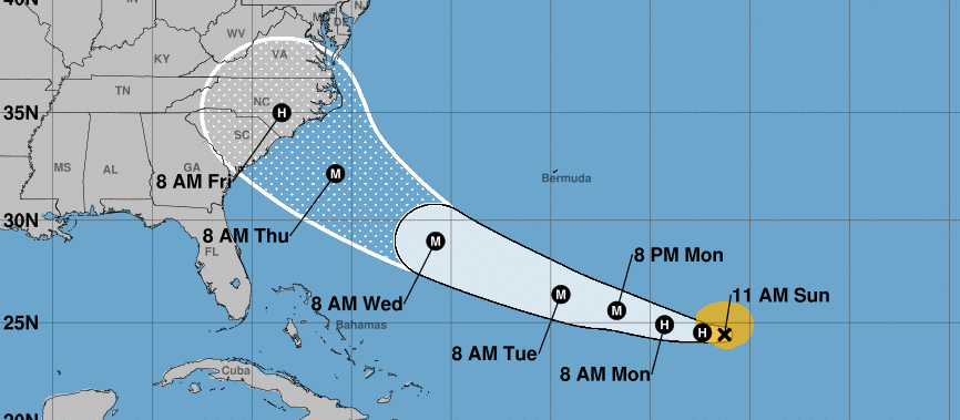
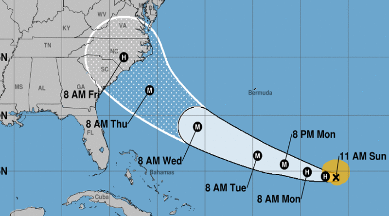
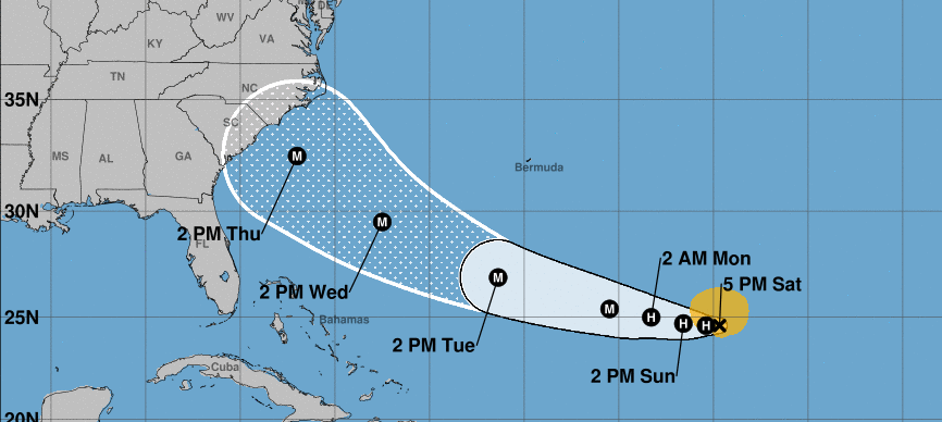
At 11:00 AM Sunday, the center of Hurricane Florence was located by a NOAA Hurricane Hunter aircraft near latitude 24.4 North, longitude 56.3 West.
Florence is moving toward the west near 6 mph (9 km/h), and this general motion is expected to continue today. A west-northwestward motion with an increase in forward speed is expected by Monday, and that motion is forecast to continue through mid-week.
On the forecast track, the center of Florence will move over the southwestern Atlantic Ocean between Bermuda and the Bahamas Tuesday and Wednesday, and approach the southeastern U.S. coast on Thursday.
Aircraft data indicate that maximum sustained winds have increased to near 75 mph (120 km/h) with higher gusts. Florence is forecast to rapidly strengthen to a major hurricane by Monday, and is expected to remain an extremely dangerous major hurricane through Thursday. Hurricane-force winds extend outward up to 15 miles (30 km) from the center and tropical-storm-force winds extend outward up to 115 miles (185 km).
The latest minimum central pressure reported by a NOAA Hurricane Hunter Aircraft is 984 mb (29.06 inches).
HAZARDS AFFECTING LAND ———————- SURF: Swells generated by Florence are affecting Bermuda and are beginning to reach portions of the U.S. East Coast. These swells are likely to cause life-threatening surf and rip current conditions. Please consult products from your local weather office.
NOAA Hurricane Center Forecast For Florance Over The Last 30 Hours
Saturday 5 AM Forecast
Saturday 5 PM Forecast

Sunday 5 AM Forecast

Sunday 11:00 AM Forecast