
SEVERE THUNDERSTORM WATCH 218 REMAINS VALID UNTIL 8 PM EDT THIS
EVENING FOR THE FOLLOWING AREAS
IN DELAWARE THIS WATCH INCLUDES 2 COUNTIES
IN CENTRAL DELAWARE
KENT
IN SOUTHERN DELAWARE
SUSSEX
IN MARYLAND THIS WATCH INCLUDES 4 COUNTIES
IN NORTHEAST MARYLAND
CAROLINE KENT QUEEN ANNE`S
TALBOT
THIS INCLUDES THE CITIES OF CENTREVILLE, CHESTERTOWN, DENTON,
DOVER, EASTON, AND GEORGETOWN.
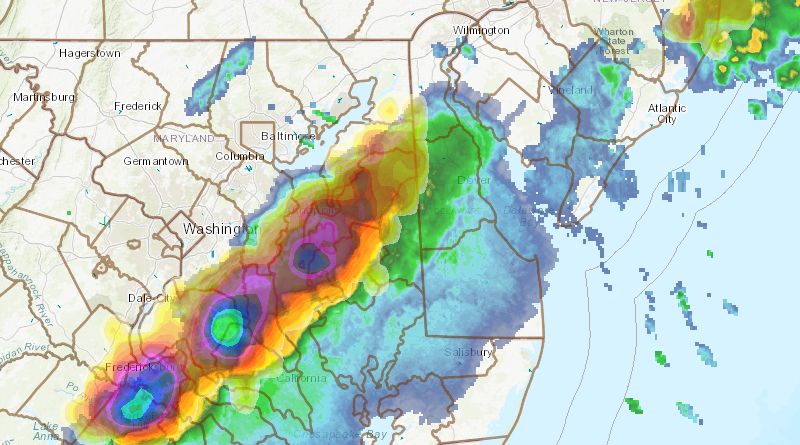
The National Weather Service in Mount Holly NJ has issued a
* Severe Thunderstorm Warning for…
Sussex County in southern Delaware…
Southwestern Kent County in central Delaware…
* Until 600 PM EDT.
* At 500 PM EDT, severe thunderstorms were located along a line
extending from Ridgely to near Matthews to Trappe to near
University Of Maryland Center For Environmental Studies to near
Taylors Island, moving east at 45 mph.
HAZARD…60 mph wind gusts and nickel size hail.
SOURCE…Radar indicated.
IMPACT…Damage to roofs, siding, trees, and power lines is
possible.
* Locations impacted include…
Georgetown, Milford, Seaford, Laurel, Harrington, Milton,
Bridgeville, Delmar, Ellendale, Gumboro, Sycamore, Andrewsville,
Blades, Greenwood, Houston, Bethel and Farmington.
PRECAUTIONARY/PREPAREDNESS ACTIONS…
For your protection move to an interior room on the lowest floor of a
building.
In addition to hail and damaging winds, frequent cloud to ground
lightning is occurring with these storms. Move indoors immediately.
Remember, if you can hear thunder, you are close enough to be struck
by lightning.