An Air Force Reserve hurricane hunter aircraft investigating
Florence this morning has found no change in the hurricane’s peak
intensity of 115 kt, even though the central pressure had decreased
a few millibars down to 943 mb. However, the aircraft data do
indicate that Florence’s inner-core wind field has expanded, with
the 50-kt wind radii now extending outward up to 100 n mi to the
northeast. Florence still has a very distinct eye in satellite
imagery, but cloud top temperatures have been waxing and waning in
the eyewall region, with slight downward trend noted in the past
hour or so. In contrast, the upper-level outflow remains impressive
and continues to expand everywhere except to the south.
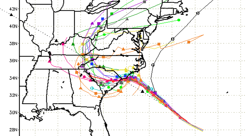
[media-credit name=”Hurricane Model Plots Provided By South Florida Water Management District” align=”aligncenter” width=”800″] [/media-credit]
Florence is now moving toward the northwest or 305/13 kt. There has
been no significant change to the NHC model guidance, including the
corrected-consensus models HCCA and FSSE, which are now virtually
on top of each other and the simple consensus model TVCA. As a
result, no changes were required to the previous NHC track. The
shortwave trough over the southern Plains seen in water vapor
imagery could end up being a significant factor as it rounds the
narrow ridge over the Tennessee Valley and is expected to erode the
ridge along the U.S. mid-Atlantic coast on days 3-5. At this time,
little change has been made to the NHC track forecast, which remains
very close to the aforementioned consensus aids through 72 hours. On
the current forecast track, the center of Florence is expected to be
near the coasts of southern North Carolina and northern South
Carolina in 48 to 72 hours and then drift westward to west-
southwestward in weak steering flow.
There is still a narrow window of opportunity for Florence to
strengthen a little when the cyclone moves over the warmest SSTs and
highest upper-ocean heat content while the shear will be the lowest
between 0600-1200 UTC tomorrow morning. After that, decreasing ocean
heat content along with the slowing forward speed of Florence should
cause at least some cold upwelling beneath the hurricane, which
should induce a gradual weakening trend. Once Florence reaches the
shallow coastal shelf waters in 72 h, land interaction and more
significant upwelling are expected, further enhancing the weakening
process. The NHC intensity forecast remains near the higher
statistical guidance through 48 hours, then follows the trend of the
decay SHIPS model after that time.
While Florence’s maximum winds are expected to weaken a little, it
is still expected to remain a dangerous major hurricane as it
approaches the coast. The threat to life from storm surge and
rainfall will not diminish, and these impacts will cover a large
area regardless of exactly where the center of Florence moves.


