
The eye of Irma passed over Barbuda, St. Barthelemy, and St. Martin
this morning, and will be moving over portions of the British and
U.S. Virgin Islands shortly. A NOAA National Ocean Service
observing site on Barbuda measured sustained winds of 103 kt with a
gust to 135 kt earlier this morning before the anemometer failed.
The station also reported a minimum pressure of 916.1 mb. A minimum
pressure of 915.9 mb was reported on St. Barthelemy. An Air Force
reconnaissance aircraft that performed a single pass through the eye
this morning reported SFMR winds of 152 kt in the northwestern
eyewall around 12Z. Assuming there are stronger winds in the
northeastern eyewall, the initial intensity remains 160 kt for this
advisory. Another Air Force aircraft is currently entering the
storm.
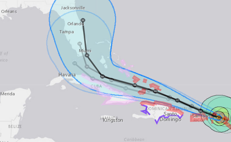
Irma is moving west-northwestward or 285/14 kt. A strong high
pressure ridge extending from the central Atlantic westward is
expected to keep Irma moving west-northwestward during the next 2
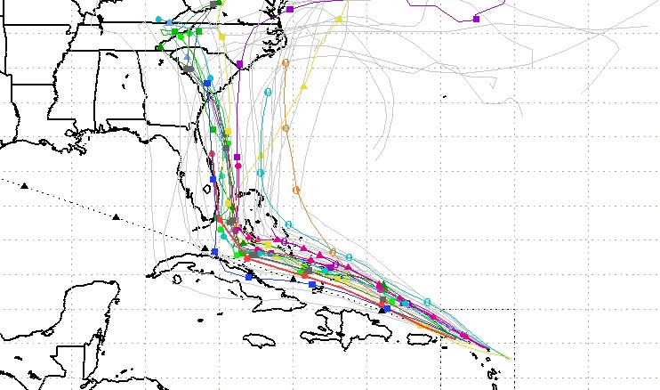
to 3 days. The track guidance is in good agreement during this
period and the NHC track is along the southern edge of the guidance
envelope in best agreement with the ECMWF and HFIP corrected
consensus model. After that time, a shortwave trough moving
southward over the east-central United States is expected to erode
the western portion of the ridge. As a result, Irma is forecast to
turn northwestward and northward, but there is still a fair amount
of uncertainty regarding the exact timing and location of
recurvature. The NHC forecast has been shifted eastward to be in
better agreement with the latest model guidance, however it should
be noted that there are numerous GEFS and ECMWF ensemble members
that take Irma over and/or west of Florida. The updated NHC track
is in best agreement with the latest ECMWF ensemble mean. Users are
reminded that the average NHC track errors at days 4 and 5 are
about 175 and 225 statue miles, respectively.
Irma is forecast to remain within favorable atmospheric conditions
and over warm waters during the next 3 to 4 days. Therefore, Irma
is likely to remain a very powerful hurricane during this time, and
the NHC intensity forecast is unchanged from the previous advisory
through day 4. Since the 120-h forecast point is now offshore, the
intensity forecast at that time has been adjusted accordingly.
Now that Irma’s eye is clearly visible in radar imagery from San
Juan, Tropical Cyclone Updates with hourly position estimates
will be issued starting at 1200 PM AST (1600 UTC).
KEY MESSAGES:
1. Irma is a potentially catastrophic category 5 hurricane and will
bring life-threatening wind, storm surge, and rainfall hazards to
portions of the northern Leeward Islands, including the Virgin
Islands and Puerto Rico today.
2. A hurricane warning is in effect for the northern coast of the
Dominican Republic, the southeastern Bahamas, the Turks and
Caicos, and portions of Haiti, with a hurricane watch in effect for
the central Bahamas and much of Cuba. Irma is likely to bring
dangerous wind, storm surge, and rainfall to some of these areas
tonight through Friday.
3. Irma could directly affect the remainder of the Bahamas and Cuba
as an extremely dangerous major hurricane later this week. Residents
in these areas should monitor the progress of Irma and listen to
advice given by officials.
4. Direct impacts from wind, storm surge, and rainfall are possible
in the Florida Keys and portions of the Florida Peninsula beginning
later this week and this weekend. However, given the forecast
uncertainty at these time ranges, it is too soon to specify the
location and magnitude of these impacts.
Source: NOAA
Image Credits: South Florida Water Management District