Hurricane Isaias Advisory 13: 5:00 AM EDT Fri Jul 31, 2020
1. Isaias will produce heavy rains and potentially life-threatening flash flooding and mudslides across the Dominican Republic, northern Haiti, Turks and Caicos, and the Bahamas. Heavy rains associated with Isaias may begin to affect South and east-Central Florida beginning late Friday night, and the eastern Carolinas by early next week, potentially resulting in isolated flash and urban flooding especially in low-lying and poorly drained areas. Isolated minor river flooding is possible in the Carolinas early next week.
2. Hurricane conditions and dangerous storm surge are expected in portions of the Bahamas today and Saturday, and Hurricane Warnings are in effect for these areas. Preparations to protect life and property should be rushed to completion.
3. Tropical storm conditions are possible along portions of the Florida east coast beginning Saturday, and a Tropical Storm Watch remains in effect. While storm surge watches are not currently needed for this area, they may be required later today if the forecast track shifts closer to the coast. Heavy rains associated with Isaias may begin to affect South Florida and east-Central Florida beginning late tonight, potentially resulting in isolated flash and urban flooding, especially in low-lying and poorly drained areas.
4. There is a risk of impacts from winds, heavy rainfall, and storm surge late this weekend from the northeastern Florida coast and spreading northward along the remainder of the U.S. east coast through early next week. The details of the track and intensity forecast remain uncertain, and it is too soon to determine the magnitude and location of these potential impacts, but interests along the entire U.S. east coast should monitor the progress of Isaias and updates to the forecast.
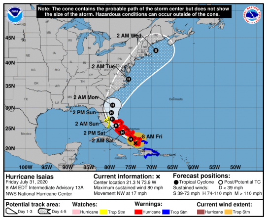
This graphic above shows an approximate representation of coastal areas under a hurricane warning (red), hurricane watch (pink), tropical storm warning (blue) and tropical storm watch (yellow). The orange circle indicates the current position of the center of the tropical cyclone. The black line, when selected, and dots show the National Hurricane Center (NHC) forecast track of the center at the times indicated. The dot indicating the forecast center location will be black if the cyclone is forecast to be tropical and will be white with a black outline if the cyclone is forecast to be extratropical. If only an L is displayed, then the system is forecast to be a remnant low. The letter inside the dot indicates the NHC’s forecast intensity for that time:
D: Tropical Depression – wind speed less than 39 MPH
S: Tropical Storm – wind speed between 39 MPH and 73 MPH
H: Hurricane – wind speed between 74 MPH and 110 MPH
M: Major Hurricane – wind speed greater than 110 MPH