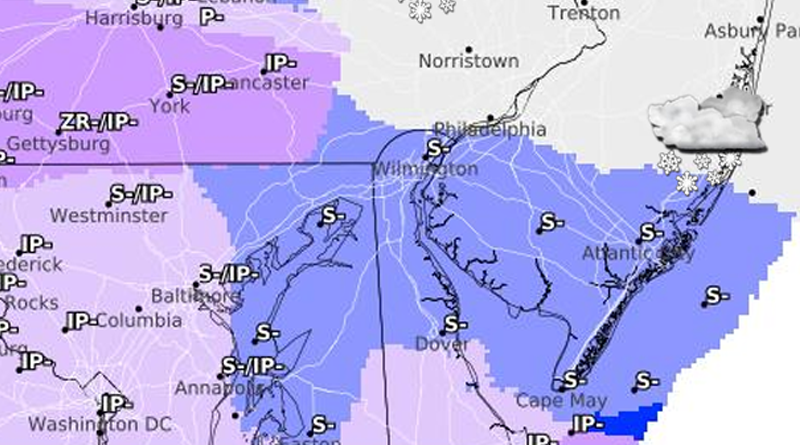
The National Weather Service in Mount Holly, New Jersey, has issued an updated forecast highlighting potential wintry conditions across the region beginning Wednesday afternoon and continuing into Thursday morning. While exact snowfall and ice accumulation amounts remain uncertain and subject to change, hazardous conditions are expected due to a combination of snow, sleet, and freezing rain.
Colder air settling into the area will initially produce snowfall, starting in the southern regions Wednesday afternoon and evening before spreading northward during the night. As warmer air moves in from the south, the snow is anticipated to transition to sleet and freezing rain before turning into plain rain by early Thursday morning.
Current projections indicate that snow and sleet accumulations will be relatively light, but freezing rain is a primary concern, creating the potential for dangerous travel conditions. The extent of freezing rain accumulation will largely depend on how long colder temperatures remain in place before the transition to rain.
Temperatures are expected to rise after sunrise on Thursday, with most areas transitioning fully to rain by late morning or early afternoon. However, the Poconos and northwestern New Jersey may experience a slower changeover due to lingering colder air.
Additionally, the forecast points to a more active weather pattern in the days ahead. Another potential wintry system could develop late Saturday into Saturday night, with another round possible next Tuesday into Wednesday.
Delaware:
- Areas Affected: Inland Sussex County, New Castle County, Kent County
- Timing: 7 PM Wednesday to 8 AM Thursday
- Details: Mixed precipitation with total snow and sleet accumulations up to 1 inch. Ice accumulations around 0.1 inch expected.
- Impacts: Hazardous travel conditions are expected during the Wednesday evening commute and Thursday morning commute.
Maryland:
- Areas Affected: Kent, Queen Annes, Talbot, Caroline
- Timing: 7 PM Wednesday to 8 AM Thursday
- Details: Mixed precipitation with total snow and sleet accumulations up to 1 inch. Ice accumulations around 0.1 inch expected.
- Impacts: Hazardous travel conditions are expected during the Wednesday evening commute and Thursday morning commute.
New Jersey:
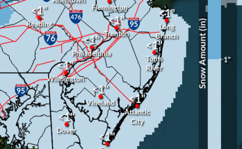
- Southern New Jersey:
- Affected Counties: Atlantic, Cape May, Cumberland, Salem
- Timing: 7 PM Wednesday to 8 AM Thursday
- Details: Light snow and sleet accumulations up to 1 inch, light glaze of ice expected.
- Impacts: Slippery roads, particularly during the Wednesday evening commute.
- Central and Northern New Jersey:
- Affected Counties: Middlesex, Western Monmouth, Ocean, Southeastern Burlington
- Timing: 11 PM Wednesday to 10 AM Thursday
- Details: Snow and sleet accumulation of up to 1 inch and a light glaze of ice.
- Impacts: Slick and hazardous road conditions affecting Thursday morning travel.
- Hunterdon, Morris Counties:
- Timing: 11 PM Wednesday to 1 PM Thursday
- Details: Snow and sleet up to 2 inches with light ice accumulations.
- Impacts: Bridges and overpasses are likely to be hazardous during Thursday morning.
- Mercer, Camden, Gloucester, Northwestern Burlington Counties:
- Timing: 11 PM Wednesday to 10 AM Thursday
- Details: Mixed precipitation with snow/sleet up to 1 inch and ice accumulation of up to 0.1 inch.
- Impacts: Hazardous road conditions expected to disrupt the Thursday morning commute.
- Somerset County:
- Timing: 11 PM Wednesday to 1 PM Thursday
- Details: Snow and sleet accumulations of up to 2 inches and light ice accumulations.
- Impacts: Hazardous travel conditions, especially on bridges and overpasses.
Pennsylvania:
- Southeast Pennsylvania:
- Affected Areas: Delaware, Philadelphia, Bucks, Montgomery, Chester Counties
- Timing: 11 PM Wednesday to 10 AM Thursday
- Details: Snow/sleet accumulation of up to 1 inch and up to 0.1 inch of ice.
- Impacts: Hazardous road conditions affecting the Thursday morning commute.
- Lehigh Valley and Poconos:
- Affected Areas: Carbon, Monroe, Berks, Northampton, Lehigh Counties
- Timing: 11 PM Wednesday to 3 PM Thursday
- Details: Up to 2 inches of snow/sleet and ice accumulations of 0.1–0.2 inches.
- Impacts: Bridges and roads are expected to be particularly hazardous, impacting Thursday travel.
Residents are advised to drive cautiously and plan for extra travel time.